Listeners:
Top listeners:
-
play_arrow
Kapital FM 92.9 The Station that Rocks!

Authorities of the Federal Capital Territory Administration, FCTA, have identified 17 new areas marked as vulnerable locations prone to flood disasters.
A recent vulnerability assessment carried out by the FCT Emergency Management Department, FEMD, listed Apo-Dutse, Damagaza, Area 3 behind Government Secondary School as some of the red spots for flood disasters in the FCT.
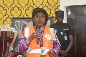
The Acting Director-General of FEMD, Florence Wenegieme, said the department carried out on the spot assessment after every heavy downpour to enable them locate and identify vulnerable locations and also notify relevant agencies for necessary actions.
According to Wenegieme the vulnerability assessment carried out across the six area councils shows that three communities in Kubwa and Byazhin areas of Bwari Area Council are also prone to flooding.
Also, Pegi community in Kuje and the market in Kwali area council have recently been listed as vulnerable locations in the territory.
Wenegieme added that FEMD ought to carry out hazard mapping every three years, but due to the constraints of inadequate funding, the department had to embark on vulnerability assessment and on the spot assessment to identify vulnerable locations.
“It is supposed to be done after every 3 years but because we have taken our jobs to be humanitarian work, we are not waiting for that money or waiting for additional funding. We cannot fold our hands and just sit down and that is why we carry out what we call the joint assessment and on the spot assessment.
“Based on that, we have been able to identify Apo-Dutse behind Cedar Crest Hospital, we have also identified Damagaza behind Gudu market, we have identified some few locations that have been eaten up by erosion in Area 3 behind Government Secondary School, all in AMAC.
“In Bwari Area Council, there are three communities. You will recall what happened in Byazhin, a man on motorcycle was washed away by flooding. We have locations in Byazhin and Kubwa, in Bwari Area Council.
“In Kuje Area Council, we have places like Pegi, and three other communities that we just identified. We have in Gwagwalada, Degwan and three other communities that we have also identified.
“In Kwali Area Council, we have three communities that were affected including the market which we just realised are also vulnerable locations.
“In Abaji, we all know what is always happening in Yaba, and lately three other communities. Thanks to the Ecological Funds, that went to the extent of constructing river bridges at such locations”.
“So far these are the new locations we have identified and have reported to the Satellite Towns Development Department. The ones in the capital city, we have reported to the Department of Engineering Services who are in charge of the provision of infrastructure in the city centre. The ones in the are councils, we have reported to the area council chairmen and at the same time to the Satellite Towns Development”.
“Like I said, as soon as we have adequate funding, we will carry out another hazard mapping to update our records,” Wenegieme said.
Remi Johnson, Edited By Grace Namiji
Written by: Safiya Wada
#kapitalfm92.9 17 Vulnerable Locations Flooding In Abuja
Similar posts
Recent Comments
No comments to show.-

DayBreak on Kapital Show
With Ife and Bendodo
Welcome to our extraordinary breakfast show, where the sun has just begun to peek over the horizon, and the world is ripe with endless possibilities. From the early hours of 5AM to 10AM on weekdays, we invite you to indulge in a symphony of captivating content that will set the perfect tone for your day.
close Top popular
Chart
-
-
play_arrow
Sunshine Tommy Blues
-
play_arrow
-
-
play_arrow
Red Frank Lee
-
play_arrow
-
-
play_arrow
Eclipse Donna May
-
play_arrow
-
Copyright Kapital FM 92.9 Abuja - The Station that Rocks!


Post comments (0)